Progetti
Projects are the main data containers on QField and QFieldCloud.
Users can create any number of projects.
Projects must contain a single .qgs/.qgz QGIS file, and may in addition contain any combination of geospatial files -- GeoPackages, Shapefiles, TIFs -- or data files such as photos, PDFs etc.
File Size Recommendations to ensure optimal performance: - Recommended Limit: For optimal performance, keep individual file sizes under 2 GB. - Absolute Maximum: The system's hard limit is 10 GB. Files larger than this will fail to process.
Larger files than this may take significantly longer to process and lead to jobs issues. It is therefore recommended to: - Divide large files into smaller pieces - Check the On-demand Attachment files download
Files cannot be shared between projects, unless shared datasets are used.
QFieldCloud projects have a name and an owner.
The owner of a project is a QFieldCloud user or an organization.
No two projects can use the same pair owner_name and project_name.
Projects can be marked as either public or private. Private projects are accessible only to users added to a project as project collaborators. Public projects are visible to, and can be downloaded by, any QFieldCloud user.
Creare un progetto
A project can be created in multiple ways:
- via QFieldCloud web interface;
- via QFieldSync in QGIS;
- via QFieldCloud-SDK;
File
Files are the skeleton on which QFieldCloud projects work.
To make a QFieldCloud project alive users need to upload at least a single QGIS project file in the .qgs or .qgz file formats.
All geospatial files must be uploaded using the same relative paths as on one's computer.
If external SVG or raster symbology is used, users must upload the corresponding files too.
Nota
QFieldCloud non supporta i progetti archiviati in file GeoPackage (.gpkg) (ma gli utenti possono comunque utilizzare i file GeoPackage per memorizzare i set di dati per i loro progetti).
La struttura tipica di un file QGIS potrebbe essere simile a questa:
project
├── data
│   ├── basemap.tif
│   ├── bees.gpkg
│   └── fields.gpkg
├── symbology
│   ├── icon.svg
│   └── line-pattern.png
├── DCIM
│   ├── bees-20220404121212.jpg
│   ├── bees-20220405040506.jpg
│   └── fields-20220405040607.jpg
├── project.qgs
├── project_attachments.zip
└── project.qml
The files in a QGIS project can be in one of the following groups by their purpose:
- QGIS project file - a
.qgsor.qgzproject file. - QGIS sidecar files - the utility files to the QGIS project file, such as
*_attachments.zipor other sidecar files. - Data source files - all your vector and raster data, such as
.gpkg,.tif,.mbtilesor other data source files. - Attachments - all your additional project data, such as
.jpg,.pdfor other files. - QField plugins - all your QField plugins, usually
.qmlfiles.
Versioni dei file
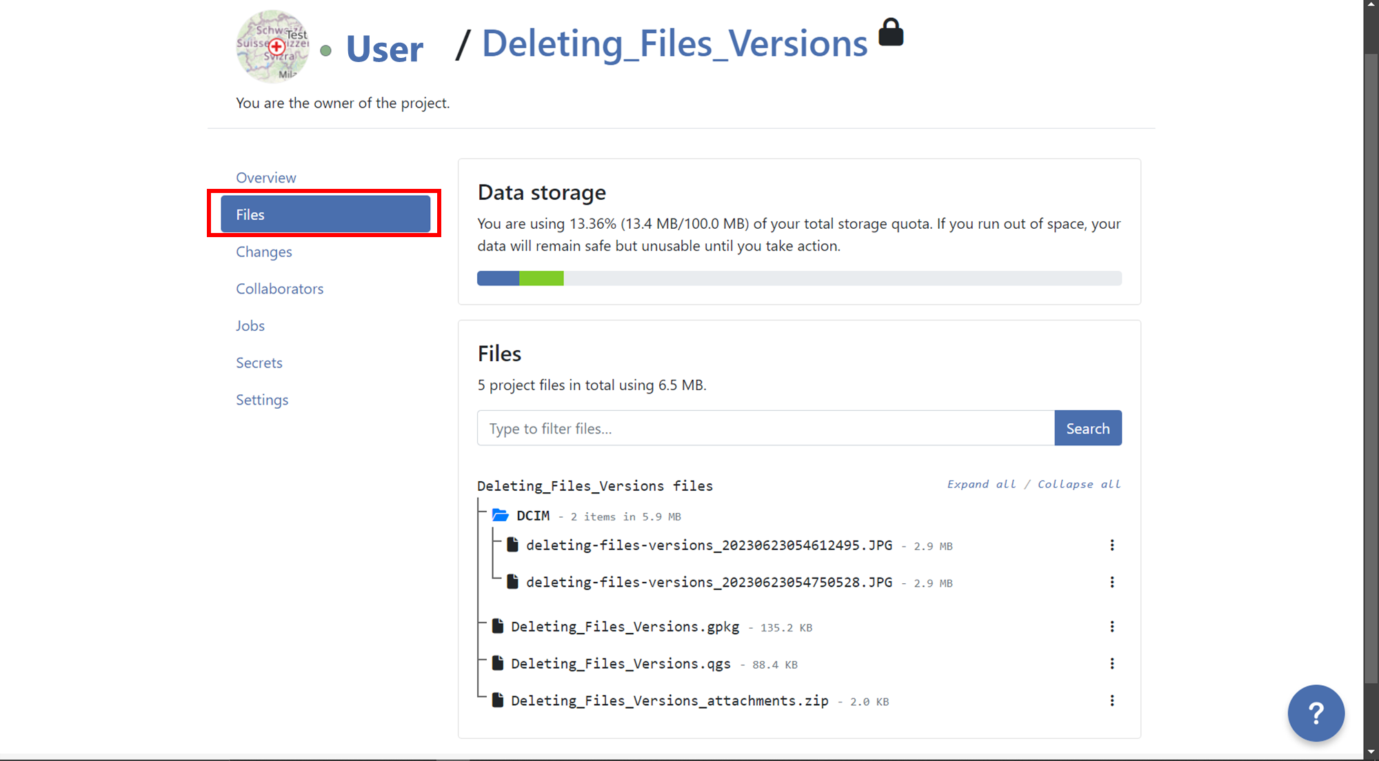
QFieldCloud uses file versioning. This allows users to restore any modified file to a previous version. Files and file versions can be found under the Files section of your projects. Subscriptions plans allow a different number of versions per file. See the qfield.cloud pricing page for further details.
Eliminazione di vecchie versioni di file
To ensure that only relevant file versions are kept, and to reduce the amount of storage needed by accounts, users can delete obsolete file versions. One can manually delete file versions from the project's File section. Each file and version can be linked to a specific QFieldCloud user who uploaded it.
Per eliminare le versioni dei file in QFieldCloud, procedere come segue:
- Go to the "Files" section of your project.
- Locate the file for which you want to delete versions.
- Click on the 3-dotted menu (⋮) on the right side of the file name.
- You will see a list of versions for that specific file.
-
Identify the version you want to delete and click on the red trash bin icon next to it.
-
Confirm the deletion when prompted, if you want to delete all versions before a specific version, you can do it activating the option "Also delete
nversion(s) older than the selected version.".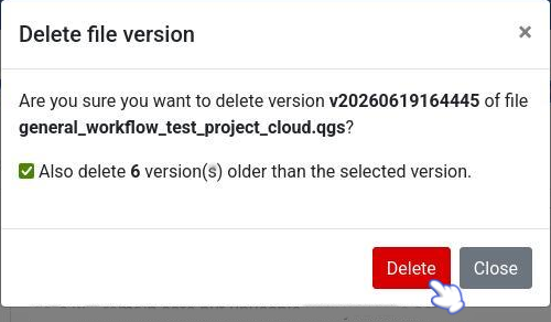
-
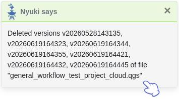
After deleting a pop up message will appear with the success and the list of versions will show just the versions that was not selected for deletion.
Collaboratori
A project collaborator is a QFieldCloud user invited to contribute to a project. A single project may have multiple collaborators. Collaborators with roles owner or admin can add more users as collaborators. Projects owned by an organization allow adding teams as collaborators. Read more about collaborator roles.
Modifiche
Changes made on vector layers and uploaded to QFieldCloud from a QField device will appear here. A change stores the difference between attributes or geometries before and after the upload.
Il registro delle modifiche indica quale metodo è stato utilizzato per il caricamento; può essere uno dei seguenti:
create- è stato creato un nuovo elemento.cancella- un elemento esistente è stato cancellato.patch- un elemento esistente è stato modificato.
Gli elementi creati e successivamente eliminati senza passare a QFieldCloud non vengono visualizzati nelle modifiche del progetto.
Nota
Le modifiche ai layer vettoriali online (PostGIS, WFS) che non hanno l'azione "Offline editing" non generano una modifica, ma modificano la sorgente dati originale directly.
Note
Modifiche ai layer vettoriali fatte in QGIS non appariranno qui.
Lavori
Maggiori informazioni su project jobs.
Segreti
Secrets are Project settings that are securely stored in an encrypted way. Jobs will automatically have access to project's secrets.
Read more about project secrets.
Impostazioni
Le impostazioni del progetto sono disponibili solo per i proprietari del progetto e i collaboratori con ruoli "admin". Settings deve essere maneggiato con attenzione in quanto gli utenti possono modificare le impostazioni sensibili del progetto ed eseguire azioni irreversibili.
- Cambia la visibilità del progetto in pubblica.
- Cambia il proprietario del progetto.
- Elimina definitivamente un progetto.
- ecc.
Warning
Actions issued from a project's settings page can lead to data loss!
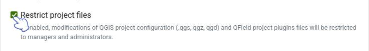
Restrict Project Files Modifications
When this setting is enabled, the ability to modify, overwrite, or upload changes to the core QGIS/QField project files (.qgs/.qgz/.qgd or QField project plugins)
are strictly restricted to collaborators with Admin or Manager roles.
Collaborators with Editor or Reporter roles will still be able to seamlessly edit data, push delta changes, and upload non-project files to the cloud like attachments (pictures, audios, videos or PDFs documents), but they will be prevented from altering the main project files. This is highly useful for ensuring field workers can synchronize data without accidentally breaking the project's layers, styling, or overall configuration.