Proyectos
Los proyectos son los principales contenedores de datos en QField y QFieldCloud.
Los usuarios pueden crear cualquier número de proyectos.
Los proyectos deben contener un único archivo QGIS .qgs/.qgz y pueden contener además cualquier combinación de archivos geoespaciales (GeoPackages, Shapefiles, TIF) o archivos de datos como fotos, PDF, etc.
File Size Recommendations to ensure optimal performance: - Recommended Limit: For optimal performance, keep individual file sizes under 2 GB. - Absolute Maximum: The system's hard limit is 10 GB. Files larger than this will fail to process.
Larger files than this may take significantly longer to process and lead to jobs issues. It is therefore recommended to: - Divide large files into smaller pieces - Check the On-demand Attachment files download
Files cannot be shared between projects, unless shared datasets are used.
Los proyectos QFieldCloud tienen un nombre y un propietario.
El propietario de un proyecto es un usuario de QFieldCloud o una organización.
No puede haber dos proyectos con el mismo par nombre_propietario y nombre_proyecto.
Los proyectos pueden marcarse como públicos o privados. A los proyectos privados sólo pueden acceder los usuarios añadidos a un proyecto como colaboradores del mismo. Los proyectos públicos son visibles y pueden ser descargados por cualquier usuario de QFieldCloud.
Crear un proyecto
Un proyecto puede crearse de múltiples maneras:
- mediante la interfaz web de QFieldCloud;
- a través de QFieldSync en QGIS;
- a través de QFieldCloud-SDK;
Archivos
Los archivos son el esqueleto sobre el que funcionan los proyectos QFieldCloud.
Para hacer un proyecto QFieldCloud vivo los usuarios necesitan subir al menos un único archivo de proyecto QGIS en los formatos de archivo .qgs o .qgz.
Todos los archivos geoespaciales deben cargarse utilizando las mismas rutas relativas que en el propio ordenador.
Si se utiliza simbología externa SVG o raster, los usuarios deben cargar también los archivos correspondientes.
Nota
QFieldCloud no admite proyectos almacenados en archivos GeoPackage (.gpkg) (pero los usuarios pueden seguir utilizando archivos GeoPackage para almacenar conjuntos de datos para sus proyectos).
La estructura típica de un archivo QGIS podría ser algo así:
project
├── data
│   ├── basemap.tif
│   ├── bees.gpkg
│   └── fields.gpkg
├── symbology
│   ├── icon.svg
│   └── line-pattern.png
├── DCIM
│   ├── bees-20220404121212.jpg
│   ├── bees-20220405040506.jpg
│   └── fields-20220405040607.jpg
├── project.qgs
├── project_attachments.zip
└── project.qml
Los archivos de un proyecto QGIS pueden estar en uno de los siguientes grupos según su finalidad:
- Archivo de proyecto QGIS - un archivo de proyecto
.qgso.qgz. - Archivos sidecar de QGIS - los archivos de utilidad del archivo de proyecto de QGIS, como
*_attachments.zipu otros archivos sidecar. - Archivos fuente de datos - todos tus datos vectoriales y rasterizados, como
.gpkg,.tif,.mbtilesu otros archivos fuente de datos. - Adjuntos - todos los datos adicionales de su proyecto, como
.jpg,.pdfu otros archivos. - Complementos QField - todos tus complementos QField, normalmente archivos
.qml.
Versiones de archivo
QFieldCloud utiliza control de versiones de archivos. Esto permite a los usuarios restaurar cualquier archivo modificado a una versión anterior. Los archivos y sus versiones se encuentran en la sección Archivos de sus proyectos. Los planes de suscripción permiten un número diferente de versiones por archivo. Consulte la página de precios de qfield.cloud para obtener más información.
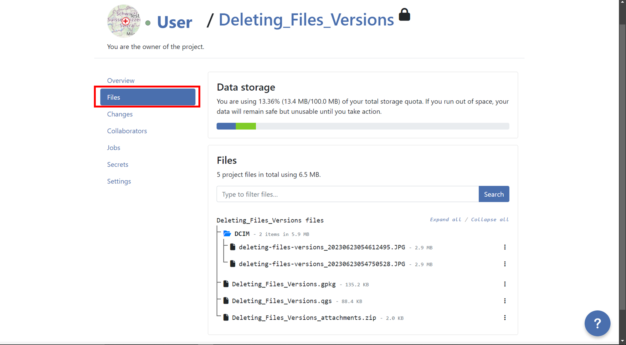
Borrar versiones de archivo antiguas
Para garantizar que solo se conserven las versiones relevantes de los archivos y reducir la cantidad de almacenamiento que necesitan las cuentas, los usuarios pueden eliminar las versiones obsoletas. Se pueden eliminar manualmente las versiones de los archivos desde la sección Archivo del proyecto. Cada archivo y versión se puede vincular a un usuario específico de QFieldCloud que lo subió.
Para eliminar versiones de archivos en QFieldCloud, sigue estos pasos:
- Go to the "Files" section of your project.
- Locate the file for which you want to delete versions.
- Click on the 3-dotted menu (⋮) on the right side of the file name.
- You will see a list of versions for that specific file.
-
Identify the version you want to delete and click on the red trash bin icon next to it.
-
Confirm the deletion when prompted, if you want to delete all versions before a specific version, you can do it activating the option "Also delete
nversion(s) older than the selected version.".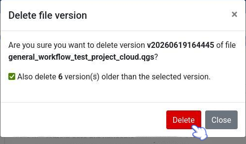
-
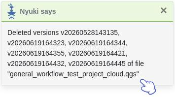
After deleting a pop up message will appear with the success and the list of versions will show just the versions that was not selected for deletion.
Colaboradores
Un colaborador de proyecto es un usuario de QFieldCloud invitado a contribuir a un proyecto. Un mismo proyecto puede tener varios colaboradores. Los colaboradores con roles de propietario o administrador pueden agregar más usuarios como colaboradores. Los proyectos propiedad de una organización permiten agregar equipos como colaboradores. Más información sobre los roles de colaborador (permissions.md).
Cambios
Los cambios realizados en las capas vectoriales y subidos a QFieldCloud desde un dispositivo QField aparecerán aquí. Un cambio almacena la diferencia entre los atributos o las geometrías antes y después de la carga.
Cambia el registro del método utilizado para la carga; puede ser uno de los siguientes:
create- se ha creado una nueva función.delete- se ha eliminado un objeto espacial existente.patch- se ha modificado un objeto espacial existente.
Los objetos espaciales que se han creado y eliminado posteriormente sin haber sido enviadas a QFieldCloud no aparecen en los cambios del proyecto.
Nota
Los cambios en las capas vectoriales en línea (PostGIS, WFS) que no tienen la acción de capa de nube "Edición fuera de línea" no generan un cambio, sino que modifican la fuente de datos original directamente.
Nota
Los cambios en las capas vectoriales realizados en QGIS no aparecerán aquí.
Trabajos
Saber más de project jobs.
Secretos
Los Secretos son configuraciones del Proyecto que se almacenan de forma segura y cifrada. Los trabajos tendrán acceso automático a los secretos del proyecto.
Lea más sobre secretos del proyecto.
Configuraciones
Los ajustes del proyecto sólo están disponibles para los propietarios del proyecto y los colaboradores con funciones de "administrador". Los Configuraciones deben manejarse con cuidado, ya que los usuarios pueden modificar configuraciones sensibles del proyecto y realizar acciones irrecuperables.
- Cambiar la visibilidad del proyecto a público:
- Cambiar el propietario del proyecto:
- Permanentemente eliminar un proyecto:
- etc
¡¡¡ advertencia Las acciones realizadas desde la página de configuración de un proyecto pueden provocar la pérdida de datos.
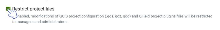
Restrict Project Files Modifications
When this setting is enabled, the ability to modify, overwrite, or upload changes to the core QGIS/QField project files (.qgs/.qgz/.qgd or QField project plugins)
are strictly restricted to collaborators with Admin or Manager roles.
Collaborators with Editor or Reporter roles will still be able to seamlessly edit data, push delta changes, and upload non-project files to the cloud like attachments (pictures, audios, videos or PDFs documents), but they will be prevented from altering the main project files. This is highly useful for ensuring field workers can synchronize data without accidentally breaking the project's layers, styling, or overall configuration.