Attribut-Eingabemaske
QField creates forms that are similar to QGIS, but with some differences. QGIS field widgets are supported on a best-effort basis and optimized for mobile use.
| Attributtyp | Unterstützung | Notiz |
|---|---|---|
| Text Edit | - HTML is not supported - Numeric input is enforced based on the field type. |
|
| Kontrollkästchen | ||
| Werteabbildung | ||
| Versteckt | ||
| Anhang | This field is combined with camera integration. It is also able to open other files like pdf and doc (if you have an appropriate viewer) Attachment (photo settings) | |
| Datum Zeit | ||
| Bereich | ||
| Beziehungen | ||
| Beziehungsreferenz | ||
| Wertebeziehung | ||
| UUID-Generator | ||
| QML / HTML Widget | ||
| Andere | Finanzierung |
Änderbar
Das Kennzeichen bearbeitbar von Feldern wird beachtet.
Letzte Werte erinnern
QField offers more fine-grained control over the last used values than QGIS, and uses its own settings instead of the QGIS ones.
Attribut-Eingabemasken unterdrücken
Die Einstellung Attribut-Eingabemaske unterdrücken wird direkt angewandt auf die QField-Eingabemaske.
Drag & Drop Designer Eingabemasken
Gruppen und Reiter von Drag and Drop Designer Eingabemasken werden unterstützt.
Gruppen und Reiter von Drag and Drop Designer Eingabemasken werden unterstützt. Im "Attributformular" können Sie Ihre Formulare mit verschiedenen Containern wie Registerkarten und Gruppen strukturieren und die Interaktivität durch die Integration einer ausdrucksbasierten bedingten Sichtbarkeit verbessern. Durch die Aktivierung des [Drag & Drop-Designers], (https://docs.qgis.org/latest/en/docs/user_manual/working_with_vector/vector_properties.html#vector-attributes-menu), erhalten Sie die Flexibilität, Attributfelder neu anzuordnen, sowie Zugriff auf Widgets, die nicht direkt an bestimmte Felder gebunden sind (z. B. HTML/QML-Widgets).
Ein Beziehungs-Widget konfigurieren
Vorbereitung am Schreibtisch
For detailed information on setting up data layer relationships in QGIS, please refer to the Setting relations between multiple layers QGIS documentation. To then control how many related items are shown in QField, see the instructions for Configuring Maximum items visibility for QField.
Das Beziehungs-Widget zeigt alle in Bezug stehenden untergeordneten Features in einer Liste an. Sie können hinzugefügt, gelöscht und geöffnet werden.
Die visuelle Identifizierung der Listeneinträge erfolgt über Ausdruck anzeigen der untergeordneten Layer.
Handhabung der Schlüssel
Since the parent's primary keys are used as foreign keys in the referencing child features, these primary keys must be safe to use even after synchronizing back to the original data. Therefore we recommend to use stable values such as UUIDs for primary keys.
Es ist möglich, bereits Kinder von einem Elternteil hinzuzufügen, der kurz davor steht, hinzugefügt zu werden. Diese Möglichkeit wird blockiert, wenn kein gültiger Primärschlüssel auf dem Eltern-Element vorhanden ist, oder die Abhängigkeiten würden verletzt. Falls das Hinzufügen des Eltern-Element abgebrochen wird, nachdem bereits einige untergeordnete Kind-Elemente hinzugefügt wurden, werden die Kind-Elemente ebenfalls gelöscht.
Viele-zu-viele Beziehungen
Bei m:n-Beziehungen, entsprechend der Kardinalitätseinstellung in den QGIS-Layer-Eigenschaften, wirkt sich das Hinzufügen, Löschen oder Öffnen eines Eintrags in der Liste direkt auf den Kind-Layer (bei direkter Kardinalität) oder die Verknüpfungstabelle (bei m:eins-Kardinalität) aus.
Der zweite Fall wird in der Regel verwendet, wenn zusätzliche Beziehungsinformationen (z. B. Prozentsätze) in der Verknüpfungstabelle vorhanden sind.

Im Falle der m:eins-Kardinalität für m:n-Beziehungen muss der Anzeigeausdruck in der Verknüpfungstabelle festgelegt werden.
Konfigurieren von Ordered-Beziehungen für QGIS und Standardwert
The Ordered Relation Editor widget enables reordering of linked child features based on a specific ordering field.
1. Installiere das Plugin
Stelle sicher, dass du das Plugin Ordered Relation Editor aus dem offiziellen Repository oder über den "Plugin Manager" in QGIS installiert hast.
2. Konfiguriere das Layout
Navigiere zum Abschnitt Attribut-Formular deiner Layer Einstellungen und stelle den Layout-Editor auf Drag and Drop Designer.
3. Das Beziehungs-Editor-Widget einrichten
In the Relation widget type dropdown, select Ordered Relation Editor. Then, configure the widget using the following settings:
-
Ordering Field: Specify the field in the child layer that will be used to determine the order of the features.
-
Description: Define an expression to display descriptive text for each child feature in the list.
-
Image Path (Optional): Provide a path to an image or icon to visually enhance the list. This is an expression that resolves dynamically.


Konfiguration des Elementschwellenwerts für wertebasierte Karten-Editor Widgets
Um die Benutzerfreundlichkeit von QField zu erhöhen, ist es möglich, den Schwellenwert für Elemente festzulegen, ab dem die Widgets des wertebasierten Karten-Editors auf eine Schaltfläche umschalten. Diese Funktion ermöglicht den schnellen Zugriff auf Elemente in QField, wenn nur wenige vorhanden sind, und bietet eine intuitivere Oberfläche, wenn eine große Anzahl von Elementen bearbeitet wird.
So aktivieren Sie die Schnittstelle der Umschalttaste
-
Öffnen Sie die Layer-Eigenschaften durch Rechtsklick auf den gewünschten Layer und die Auswahl von 'Eigenschaften' über das Kontextmenü.
-
Navigieren Sie zur Registerkarte QFeld im Dialogfeld Layer-Eigenschaften.
-
Hier finden Sie eine Option, mit der Sie die Anzahl der Elemente angeben können, die den Übergang zu einer Umschalttaste-Schnittstelle auslösen sollen. Geben Sie den gewünschten Schwellenwert entsprechend Ihren Bedürfnissen ein.


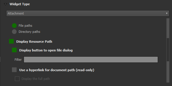
Widget für Anhänge konfigurieren
Vorbereitung am Schreibtisch
Der Bedienelementtyp Anhang wird für Felder verwendet, die den Pfad zu Dateien speichern.
Es kann verwendet werden, um:
- Fotos anzeigen und aufnehmen oder Bilder aus der Galerie hinzufügen
- Zuhören und Aufnehmen von Soundclips
- Anhören und Aufnehmen von Videos
- Links zu externen Dateien wie PDFs oder Dokumenten anzeigen


Der Pfad sollte auf relativ gesetzt werden. Die Bilder, Audios, Videos, PDFs und Dokumente werden dann in einem Unterverzeichnis des Projekts gespeichert, auf das der im Textfeld gespeicherte Link verweist.
Anmerkung
QGIS 3.30 oder neuer ist für die Audio- und Video-Funktion nötig.
In QField werden die Anhänge angezeigt. Durch Anklicken des Symbols wird die Kamera- oder Audioaufnahme gestartet, um die Bilder, Videos oder Audios mit einer neuen Mediendatei zu aktualisieren.

Bei der Synchronisierung muss auch das Unterverzeichnis mit den Bildern, Videos, Audios, PDFs und Dokumenten kopiert werden.
Die Option Hyperlink im Bedienelement Anhang deaktiviert die Kamerafunktion und aktiviert einen Hyperlink zum Öffnen eines Dokuments (pdf, doc, ...).
Konfigurierbarer Anhang-Pfad
Vorbereitung am Schreibtisch
QFieldSync bietet die Möglichkeit, den Pfad von Anhängen zu konfigurieren.
- Gehe zu QFieldSync Plugin > Layer-Eigenschaften
Verwenden Sie Ausdrücke, um den Pfad für die Anhänge anzugeben. Standardmäßig werden die Bilder im Ordner "DCIM", Audioaufnahmen werden im Ordner "Audio" und Videos im Ordner "Video" mit einem Zeitstempel als Namen gespeichert.

Konfigurieren Sie ein Wertrelations-Widget
Vorbereitung am Schreibtisch
Das Widget Wertrelation bietet Werte aus einer verwandten Tabelle in einer Combobox an. Sie können Layer, Schlüsselspalte und Wertspalte auswählen. Es sind mehrere Optionen verfügbar, um das Standardverhalten zu ändern: Nullwert zulassen, nach Wert ordnen und Mehrfachauswahl zulassen. Das Widget zeigt eine Dropdown- oder Mehrfachauswahlliste mit den referenzierten Merkmalen an.
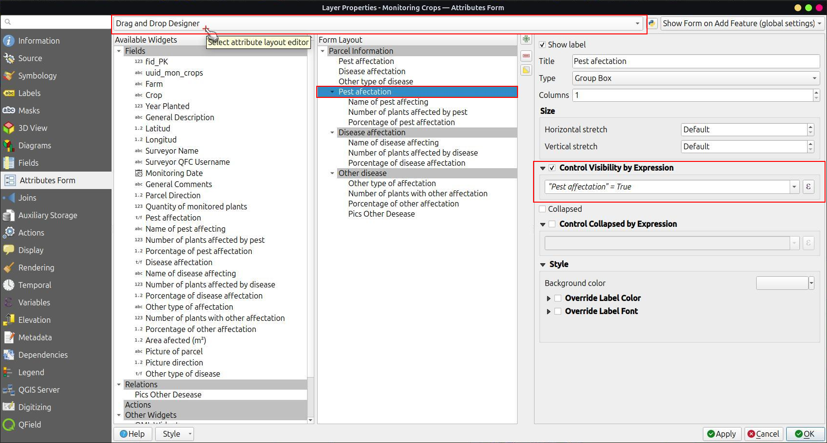
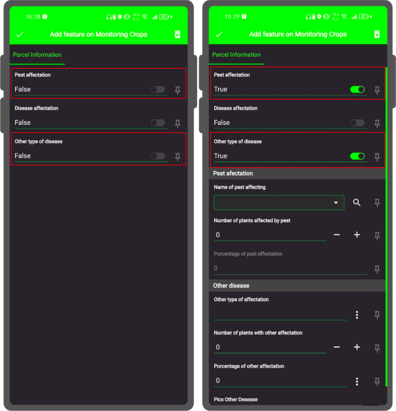
Konfigurieren der bedingten Sichtbarkeit
Vorbereitung am Schreibtisch
Gruppen können auf der Grundlage eines Ausdrucks ausgeblendet werden. Dies ist nützlich, wenn bestimmte Attribute nur unter bestimmten Bedingungen erforderlich sind. Stellen Sie sich als Beispiel die Abbildung von Bäumen vor. Einige von ihnen könnten eine Krankheit haben, und Sie haben eine Liste möglicher Krankheiten. Um die Eingabemaske nicht mit vielen Feldern zu überladen, erstellen Sie eine Gruppe und konfigurieren Sie einen Sichtbarkeitsausdruck für diese Gruppe "Krankheiten". Fügen Sie ein Feld "Krankheit" mit einem Kontrollkästchen hinzu. Nur wenn das Kontrollkästchen markiert ist, steht Ihnen die Liste der Krankheiten zur Verfügung.

Mal sehen, was wir in dem Feld sehen:
Beschränkungen definieren
Vorbereitung am Schreibtisch
Attributfelder können mit Beschränkungen versehen werden. Beschränkungen sind Ausdrücke, die zu wahr (oder 1) ausgewertet werden müssen, um das Formular speichern zu können. Beschränkungen werden für jedes Feld einzeln konfiguriert
und es kann eine Beschreibung hinzugefügt werden, die angezeigt wird, wenn eine Beschränkung nicht erfüllt ist.

Übliche Anwendungsfälle
Du kannst keinen Höhenwert eingeben, der höher ist als der höchste Berg in diesem Land.
"elevation" < 5000
Es ist nötig, eine Bezeichnung einzugeben.
"identifier" IS NOT NULL
Definiere Vorgabewerte
Vorbereitung am Schreibtisch
Für Felder können Vorgabewerte eingestellt werden. Die Vorgabewerte werden in die Attribut-Eingabemaske eingefügt, wenn ein neues Feld angelegt wird. Sie sind sichtbar und können geändert werden, solange das Feld bearbeitbar ist. Sie können auf der Geometrie oder auf Ausdrucksvariablen basieren.

Bei der Erstellung von Ausdrücken für Projekte, die mit QField verwendet werden sollen, wird empfohlen, Layernamen und nicht Layer-IDs zu verwenden. Diese Empfehlung rührt daher, dass bei der Projektkonvertierung mit QFieldSync die resultierenden Layer möglicherweise unterschiedliche IDs erhalten, was zu falschen Ausdrucksauswertungen führen kann. Durch die Verwendung von Layernamen stellen Sie sicher, dass Ausdrücke über verschiedene Projektzustände hinweg konsistent und genau ausgewertet werden.

Zusätzliche Variablen
Weitere Informationen über die Speicherung von Informationen zu Ihrer Position in den Objektattributen finden Sie in der entsprechenden GNSS Dokumentation.
Für QFieldCloud-Benutzer können zwei Variablen in Ausdrücken verwendet werden, die die Standardwerte der Attribut-Eingabemaske enthalten:
- @cloud_username gibt den Namen des aktuell eingeloggten QFieldCloud-Benutzers aus.
- @cloud_useremail gibt die E-Mailadresse der aktuell eingeloggten QFieldCloud-Benutzers aus.
Übliche Anwendungsfälle
Positionsinformationen als Variable einbinden:
@position_horizontal_accuracy
Aktuelles Datum und Zeit einfüllen.
now()
Die Länge der digitalisierten Linie einfügen:
length($geometry)
Globale Variablen auf dem Gerät konfigurieren und verwenden.
@operator_name
Wenn du einen Regionalcode basierend auf dem Ort zuweisen möchtest, an dem ein neues Objekt eingefügt wird, kannst du dies mit einem Aggregatausdruck tun:
aggregate( layer:='regions', aggregate:='max', expression:="code", filter:=intersects( $geometry, geometry( @parent ) ) )
So transformierst du die von \@position_coordinate erhaltenen Koordinaten in das Koordinatensystem deines Projektes:
x(transform(@position_coordinate, 'EPSG:4326', @project_crs ))
y(transform(@position_coordinate, 'EPSG:4326', @project_crs ))
::: {#Snapping_Ergebnisse} Wenn Sie die Ergebnisse des Snappings nach dem Zeichnen einer Linie verwenden möchten, können Sie die Variable [\@snapping_results]{.title-ref} nutzen. Der folgende Code extrahiert den Wert des Attributs [id]{.title-ref} der Snapping Übereinstimmung mit dem ersten Punkt einer Linie. :::
with_variable(
  'first_snapped_point',
  array_first( @snapping_results ),
  attribute(
    get_feature_by_id(
      @first_snapped_point['layer'],
      @first_snapped_point['feature_id']
    ),
    'id'
  )
)
In Wertbeziehungen und im Widget für Beziehungsreferenzen suchen
Es ist möglich, Werte in einer Wertrelation- oder einem Beziehungssreferenz-Widget zu suchen, indem man die Lupe neben dem Feld benutzt.
Anmerkung
Definieren Sie den Anzeigeausdruck für die betreffenden Layer. Dieser wird für die Suche nach Features verwendet. Dies wird unter Vektorlayer-Eigenschaften > Anzeige konfiguriert.
Auto-Vervollständigen Wert konfigurieren
Vorbereitung am Schreibtisch
Das Kontrollkästchen "Vervollständigung verwenden" muss aktiviert sein, um die automatische Vervollständigung in der Wertebeziehung nutzen zu können.

Hier ein Video, das zeigt, wie es in QField funktioniert

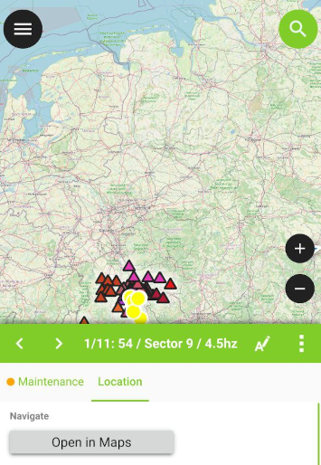
Definiere ein QML-Bedienelement
Benutzerdefinierte QML-Widgets können nützlich sein, um erweiterte Aktionen in Eingabemasken zu integrieren. In diesem Beispiel fügen wir eine Schaltfläche hinzu, die eine Karten- und Navigations-App eines Drittanbieters öffnet. Dies ist nützlich, um z. B. Turn-by-Turn-Navigationen auf der geräteeigenen App für den Benutzer zu öffnen.
import QtQuick 2.0
import QtQuick.Controls 2.0

Button {
    width: 200
    height: width/5
    text: "Open in Maps"
    onClicked: {
        Qt.openUrlExternally(expression.evaluate("'geo:0,0?q=' || $y || ',' || $x"));
    }
}
Der obige URI 'geo' ist für Android angepasst. Für Apple Maps kann die URI geändert werden in 'geo:' || $y || ',' || $x.