Geofencing
QField includes built-in geofencing functionality to alert or inform users when their GNSS location enters or exits predefined polygon boundary areas. You can also prohibit feature digitizing when a geofencing alert is active. Configure geofenced boundaries in QGIS using QFieldSync.
Defining Geofenced Areas
Project Manager
Workflow
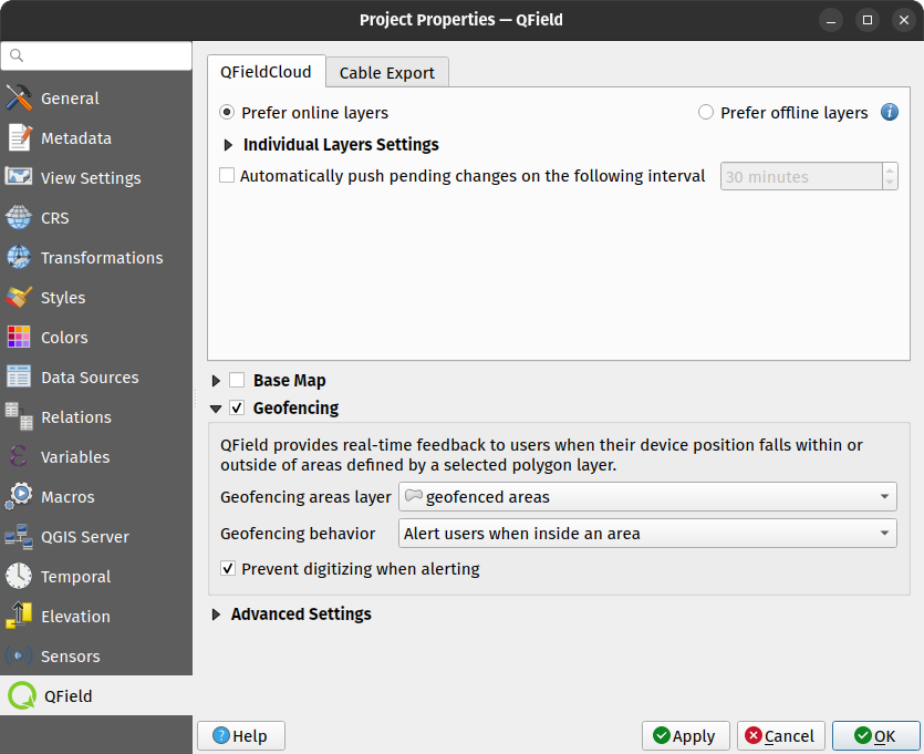
- In QGIS, navigate to Project > Properties... > QField.
- Enable the Geofencing option.
- Select the polygon vector layer to use as a geofence boundary.
- Select a geofencing behavior:
- Alert users when inside an area": Displays an alert notification whenever a user enters a defined geofence polygon.
- Alert users when outside all areas": Displays an alert notification whenever a user exits defined geofence polygons.
- Inform users when entering and leaving areas": Displays notifications whenever a user enters or exits defined geofence polygons.
- (Optional) Enable options to prohibit adding new features inside or outside the selected geofence area.
Geofencing Alerts in the Field
Fieldwork
When QField triggers a geofencing alert, a glowing red circle displays in the bottom-right corner of the screen. This visual cue remains active until the alert condition ends. On supported mobile devices, haptic vibration alerts accompany on-screen notification messages indicating which geofenced areas were entered or exited.
When digitizing restrictions are enabled, QField automatically hides the digitizing toolbar while a geofencing alert is active to prevent accidental data entry outside or inside designated zones.