プロジェクトの選択
QField has a file selector that allows to open a project from the device locally. To open files from the cloud see QFieldCloud .
Note
Starting with Android 11 apps are denied full access to main and external storage content. For QField, this means direct access to projects and datasets transferred and/or downloaded into storage folders is not possible anymore. You can know more about QField storage access.
You have to import project folders or individual datasets into the app-dedicated storage location <drive>:/Android/data/ch.opengis.qfield/files/QField where it has unrestricted read/write access.
With that behavior importing from external SD cards or providers that work with remote files (e.g. Google Drive) are supported as well.
警告
QFieldをアンインストールすると、アプリフォルダも削除されますのでご注意ください。アップデートすると残ります。
ローカルプロジェクトをインポートして開く
フィールドマーク
ローカルファイルを開く(メニューボタン > 開く)と、"QFieldファイルディレクトリ"、"インぽイートされたデータセット"、"インポートされたプロジェクト "という新しいフォルダと、右下のプラスボタンからアクセスできるドロップダウンメニューが表示されます。

ドロップダウンメニューには、プロジェクトやデータセットのインポート方法が表示されます: フォルダからプロジェクトをインポート、ZIP(アーカイブ)からプロジェクトをインポート、(個別の)データセットをインポート。
フォルダまたはZIPアーカイブからプロジェクトをインポート
When importing a project from a folder or a ZIP archive, you will be asked to grant permission for QField to read the content of a given folder on the device’s storage via a system folder picker. When the folder or the archive is selected, QField copies the content (including its sub-folders) into the app’s ‘Imported projects’ location. You can then open the project from there.
ドロップダウン・メニューから指定したフォルダを再インポートすると、同じフォルダ名の既存のプロジェクトは上書きされます。これにより、ユーザーはプロジェクトを更新することができます。
警告
地物の編集、追加、削除は、インポート時に選択した元のフォルダではなく、インポートしたプロジェクトのデータセットに保存されることに注意してください。
データセットのインポート
You can also import individual datasets. You will be asked to select one or more files via a system file picker, which will be copied into the "Imported datasets" folder. You have to ensure that all sidecar files are selected when importing (e.g. a shapefile dataset would require you to select the .shp, .shx, .dbf, .prj, and .cpg files).
お気に入りのディレクトリ
In the first screen of the file selector, there is a section showing the favorite directories. To add a directory to the favorites, long click in the file selector on the directory name. To remove an entry from the favorites, long click on the entry in the favorites list.
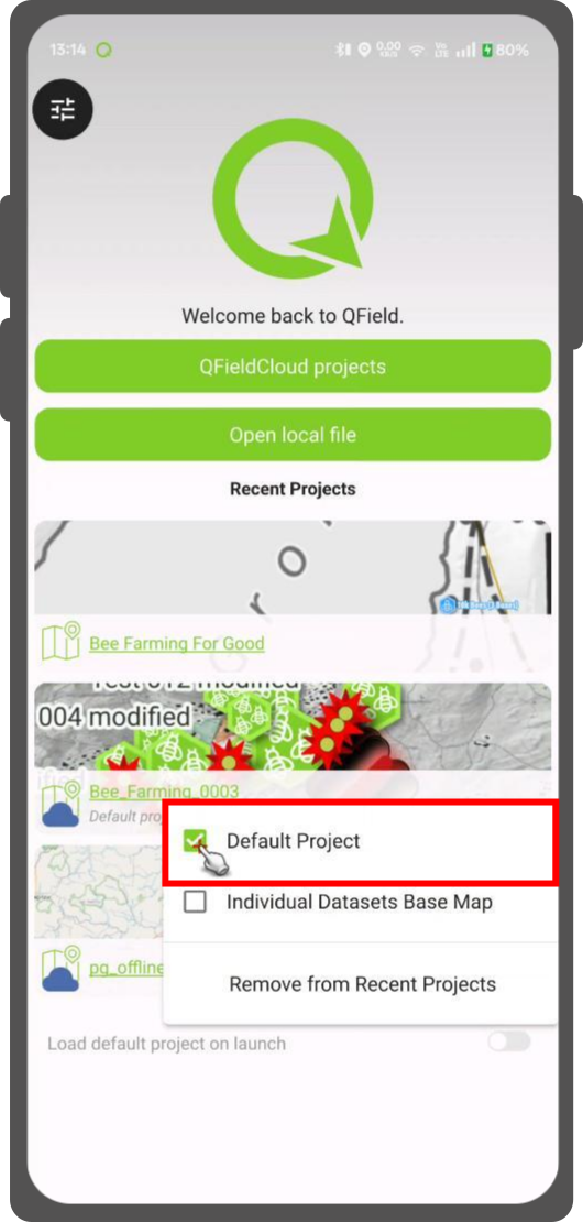
Set Default Project
This functionality allows you to set a specific project to be used as the default basemap whenever you open individual datasets. This is useful when a QFieldCloud project should be used as a basemap.
How to Set a Default Project
- In the welcome screen Recent Projects list.
- Press long on the project you wish to set as your default basemap.
- From the context menu that appears, select Set as Default Project.
Basemap Loading Logic
When you open an individual dataset, the application will now determine which basemap to load based on the following hierarchy:
- Default Project: The application will first check if a default project has been set. If so, it will be used as the basemap.
- Basemap File: If no default project is set, the application will look for a
basemap.{qgs/.qgz)file within theQFielddirectory on your device. If found, this project will be used. - OpenStreetMap: If neither a default project nor a basemap file is found, a default OpenStreetMap XYZ layer will be loaded as the basemap.
変更されたプロジェクトやデータセットを取得する
デスクトップの準備
Imported projects and datasets can be accessed directly using a USB cable. The location on storage is displayed in the top navigation bar when opening a local file.
USBケーブルでコンピュータに接続されたほとんどのデバイスでは、パスは<drive>:/Android/data/ch.opengis.qfield/files/となり、この中に「インポートされたデータセット」と「インポートされたプロジェクト」の両方のフォルダがあり、その中に編集したコンテンツがあります。
送信する
フィールドマーク
You can share and send the datasets straight from QField using Android APIs. This allows for the sending of edited datasets directly to third party apps (Gmail, Drive, Dropbox, Nextcloud, your favourite messenger app, etc.).
