Hakupalkki
Qfield on varustettu näppärällä hakupalkilla, joka mahdollistaa kohteiden hakemisen projektin vektoritasoista, kohdentaa syötettyihin koordinaatteihin ym.
Käyttö
Maastotyö
Paina hakunappia näytön oikeasta yläkulmasta avataksesi laajennetun hakuikkunan.
Vektoritasojen hakeminen
Hakupalkkiin syötettyä arvoa käytetään kohteiden etsimiseen, joissa ominaisuustietokentän arvo vastaa hakua. Haussa tulee käyttää vähintään kolmea merkkiä.
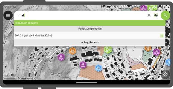
Active Layer Search Feature Matching
The active layer search functionality enhances search efficiency by focusing exclusively on the currently active layer and specific fields within it.
To start a search, simply type f followed by your search term. This helps you quickly find items by searching only the active layer. It scans feature names and all text and number fields for matches. When it finds one, both the attribute's name and value are highlighted. You'll also see the feature's name in the search results below. To narrow down your search to a specific field, type: f @ATTRIBUTE_NAME search-term. This targets your search to that field.
QR-koodilla hakeminen
Lisäksi sinulla on mahdollisuus käyttää koodin skannaustoimintoa tähän tarkoitukseen.
When click on the "Scan code" will trigger QField's code reader, initiating the scanning process to decode the code.
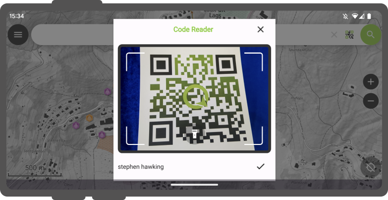
Once you are content with the scanned information, you can simply click on the checkmark (✔️) OK button to initiate a search for that specific string(In this example, the code corresponds to a user identifier that is associated with various features in a project dataset).
For distinct outcomes, is recommend encoding your feature UUIDs. This will allow us to promptly locate the relevant items.
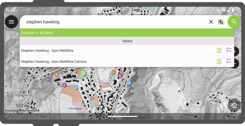
Toisiaan vastaavat ominaisuudet näkyvät tulosluettelossa ja tarjoavat sinulle kaksi mahdollista toimintoa :
- Napauta tuloksessa olevaa nimeä näyttääksesi ominaisuuden kartalla (ominaisuus korostetaan keltaisella).
- Napauta Attribuutit näppäintä avataksesi sen attribuutit.
Etsi NFC:n avulla
In addition, the Code Reader offers the capability to read NFC text tags.
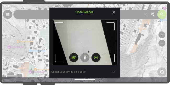
Note
While both the QR code camera and the NFC text tag detector are enabled by default when you open the Code Reader. You have the flexibility to disable either of these features to ensure that your device's battery is not used unnecessarily to activate hardware that you may not need at the moment.
Siirry koordinaatteihin
Sinun on mahdollista siirtyä hakupalkkiin syötettyihin koordinaatteihin syöttämällä hakuun leveysaste, pituusaste koordinaatit (WGS84 koordinaatit). Sinun on myös mahdollista syöttää käynnissä olevan projektin käytössä olevan koordinaattijärjestelmän koordinaatit.
Once QField identifies the entered value as a coordinate, tap on the coordinates in the result to move the map canvas to that point.
Siirry spatiaaliseen kirjainmerkkiin
The search bar also matches saved spatial bookmarks. The entered text will be matched against user-saved bookmarks as well as embedded bookmarks with the currently opened project.
The matching bookmarks will appear in the results list. Tapping on one bookmark will re-center the map canvas to match the bookmark's extent.
Lausekelaskin
QField's search bar also acts as a nifty calculator, whereas entered text can be treated as expressions, with their returned value shown in the result list with the possibility of copying the value to the clipboard.
To trigger the calculator, a = * (i.e. equal sign followed by a space) prefix is needed. For example, = 20 + 5* would return a value of 25.
Pro-tip: use the aggregate() expression function to calculate statistics against vector layers. For example, calculating the total area covered by a polygon layers can be done by typing = aggregate('my_layer','sum', $area).
Konfiguroi haku QGISissä
Työaseman valmistelu
By default, all vector layers are searchable. When configuring your project in QGIS, it is possible to exclude vector layers from search results. To do so, open the project properties dialog and switch to the Data Sources panel, where you will be presented with a layers capabilities table widget. From there, use the Searchable checkbox to include/exclude specific layers.