Paikannus (GNSS)
QField can make use of the internal GNSS (Global Navigation Satellite System, like GPS, GLONASS, Galileo or Beidou). QField can also connect to external antennas through NMEA streams over Bluetooth, TCP, or UDP connection.
GNSS-laitteet pystyvät myös mittaamaan korkeuden nykyisen 2D-sijainnin vieressä maan pinnalla.
Visualisointi
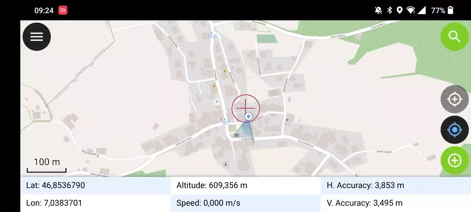
Kun paikannus on aktivoitu, sijaintisi näkyy kartalla sinisenä. Sijaintisi näkyy joko sinisenä pisteenä, jos olet paikallaan, tai nuolena, joka ilmaisee liikesuunnan, jos olet liikkeessä.
Sininen säde osoittaa laitteesi nykyisen suunnan, jos laitteessa on sisäänrakennettu magneettinen kompassi.
Ympyrä nykyisen sijaintisi ympärillä osoittaa paikannuslaitteen ilmoittaman tarkkuuden.
Määritys
The following settings are available in QField settings' positioning tab.
Mittaa (M) arvo
When digitizing a geometry onto a vector layer that contains an M dimension, QField will add a measurement value to individual vertices whenever the coordinate cursor is locked to the current position.
By default, the value will represent the captured position's timestamp (milliseconds since epoch). You can change this value using the combo box in the settings' positioning tab.
The available values to chose from are timestamp, ground speed, bearing, horizontal accuracy and vertical accuracy as well as PDOP, HDOP and VDOP.
Tarkkuusvaatimus
Mittauksille voidaan määrittää pienin haluttu tarkkuus. Laatu ilmoitetaan kolmessa luokassa, huono (punainen), ok (keltainen) ja erinomainen (vihreä). Nämä värit näkyvät pisteinä GNSS-painikkeen päällä.
The thresholds can be defined in the settings' positioning tab.
If the Enable accuracy requirement setting is activated, you will not be able to collect new measurements with the coordinate cursor locked to the current position with an accuracy value which is bad (red).
Antennikorkeuden kompensaatio
Käytössä olevan antennipylvään korkeus voidaan määrittää asetuksissa. Kaikki mitattu korkeus korjataan tällä arvolla.
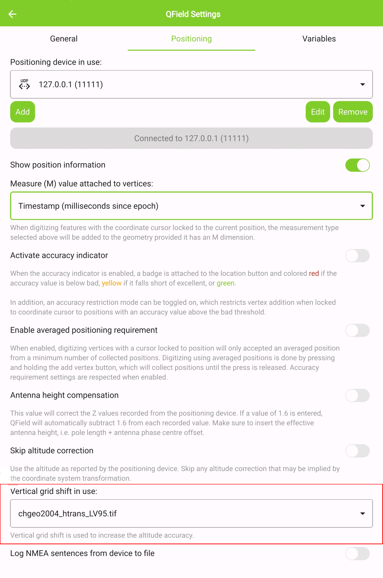
Korkeuden korjaus / pystysuora ruudukon siirto
Altitude values can be corrected with vertical grid shift files to calculate orthometric height.
Vertical grid shift files have to be made available to QField by putting them into the QField app folder [App Directory]/QField/proj.
Kun ruudukon siirtotiedosto on sijoitettu sinne, se on käytettävissä QFieldissä Paikannusasetukset kohdassa Korkeusruudukon siirto käytössä.
If you are using altitude correction and an external positioning device is used, consider turning Use orthometric altitude from device off.
The formats currently supported are:
- GeoTIFF (.tif, .tiff)
- NOAA Vertical Datum (.gtx)
- NTv2 Datum Grid Shift (.gsb)
- Natural Resources Canada's Geoid (.byn)
Example: Netherlands - ETRS89 to NAP
For transformations involving the Dutch NAP (Normaal Amsterdams Peil) vertical datum, you'll need the official grid file from NSGI.
-
Download the file: Get
nlgeo2018.gtxdirectly from the NSGI website. -
Place the downloaded
.gtxfile into the directory [App Directory]/QField/proj. This is independent of whether you are using QFieldCloud or not.
Example: Switzerland - CH1903+/LV95
To get precise altitude data for Cadastral Surveying in Switzerland (LV95), you must use the geoid correction grid from Swisstopo.
The official file comes in an .agr format and must be converted to .gtx (NTv2 Grid Shift File) before it can be used.
Other raster formats like (.tiff) can also be used
-
Download the "Geoid OGD" dataset from Swisstopo under the following link Download Link: Geoid OGD from Swisstopo.
-
Unzip the archive to retrieve the file:
chgeo2004_htrans_LV95.agr. -
Convert the file using the using the gdal_translate algorithm with one of the following options:
Method 1: QGIS Graphical User Interface (GUI)
-
In QGIS, open the Processing Toolbox panel.
-
Navigate to GDAL > Raster conversion > Translate (Convert format) tool.
-
Configure it with your needed requirements:
-
Input layer: Select your
chgeo2004_htrans_LV95.agrfile. -
Output file: Click "Save to File..." and name your output file with a
.gtxextension (or other format needed), for example,chgeo2004_htrans_LV95.gtx.
-
-
Click Run. The other default settings are typically sufficient for this conversion.
![]()
Method 2: Command Line (qgis_process)
For automation or users who prefer the command line, qgis_process is a great option.
- Open your terminal and run the following command, adjusting the paths to your files.
qgis_process run gdal:translate --INPUT="/path/to/your/chgeo2004_htrans_LV95.agr" --OUTPUT="/path/to/your/chgeo2004_htrans_LV95.gtx"
Method 3: PyQGIS Script
You can also perform the conversion programmatically within the QGIS Python Console or a standalone script.
import processing

input_grid = '/path/to/your/chgeo2004_htrans_LV95.agr'
output_grid = '/path/to/your/chgeo2004_htrans_LV95.gtx'

processing.run("gdal:translate", {
    'INPUT': input_grid,
    'OUTPUT': output_grid
})

print(f"Successfully converted grid to: {output_grid}")
Maastotyö
-
Copy the
chgeo2004_htrans_LV95.gtxfile to the directory [App Directory]/QField/proj on your mobile device. -
Under the QField settings, select the file as the vertical grid shift correction file: Main menu > three dots > Settings > Positioning
-
Enanble your GNSS device. it will directly center to your current location once the positioning information is available.
-
Change to edit mode and press on the target button - the cross in the center means it is using GNSS positioning.
A long press on the GNSS button will show the positioning menu.
Inside the menu you can turn on the Show position information which will show the current coordinates that are reprojected into the CRS of your project along with the precision information.
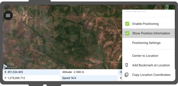
Note
Jos näet WGS 84 lat/lon -tiedot projektisi CRS:n tietojen sijaan, sinulla ei
todennäköisesti ole vielä signaalia.
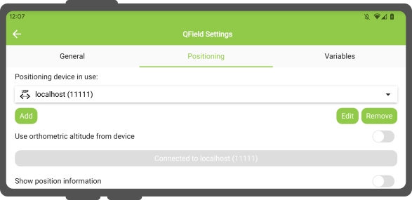
Using an external GNSS Receiver
Maastotyö
QField supports connecting to external GNSS positioning devices via NMEA streams through Bluetooth, TCP, or UDP connections.
In Settings > Positioning, you are able to manage and swithch between your internal and saved external GNSS devices.
The breakdown of connections support by platform is as follow:
| Android | iOS | Windows | Linux | MacOS | |
|---|---|---|---|---|---|
| Bluetooth | * | ||||
| TCP | |||||
| UDP | |||||
| Sarjaportti |
(*) Bluetooth support on Windows occurs through the virtual serial port automatically created by the operating system when it connects to the GNSS device.
The NMEA sentences currently supported are GGA, RMC, GSA, GSV, GST, VTG, HDG and HDT.
Note
Make sure no other app like mock location providers are using the same connection.
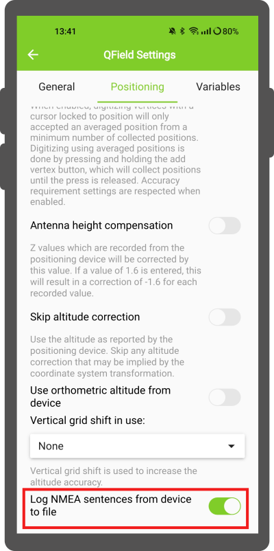
External receiver log
In Settings > Positioning if you have selected an external receiver as the positioning device, you will find a switch Log NMEA sentences from device to file.
If this is activated, all NMEA sentences coming from external positioning devices will be logged to a file.
The logs will be placed in [App Directory]/QField/logs.
Note
Be aware that if the log is always turned on, it will fill up all the storage.
Valesijainti
Maastotyö
On mahdollista tarjota valesijainti erillisen Android-sovelluksen kautta QFieldiin. Tähän on useita vaihtoehtoja, yksi niistä on Android NTRIP Client.
Jotta voit käyttää tätä, sinun on otettava valesijainnit käyttöön Android-laitteellasi.
Keskimääräinen paikannustoiminto
Maastotyö
Note
The coordinate cursor must be locked to the current location via the Lock to position button
On toiminto, jonka avulla voit digitoida käyttämällä keskiarvoisia sijainteja.
Kysely alkaa pitämällä Lisää taitepiste -painiketta painettuna, jolloin paikkojen kerääminen alkaa.
During the collection, an indicator will appear on top of the coordinate cursor showing the number number of the collected positions. If an averaged position minimum count requirement is active, a progress bar will also be present indicating the progress towards meeting that requirement.
- To activate direct to side "Dashboard" > Settings > Positioning
- Shortly tap where you want to collect points and QField will automatically add the averaged position once the minimum count is met.
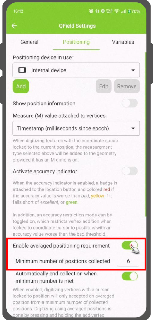
Note
When using @gnss_* or @position_ variables on averaged positions, the variable will also represent the average over all collected samples.
Sijaintimuuttujat
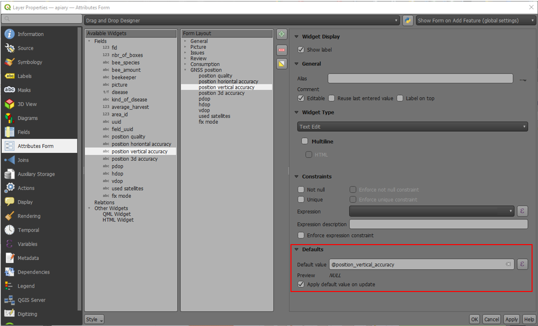
You can get the positioning information both of your internal and external device by specifically configuring your attribute form.
These variables are commonly used as part of default values expressions for fields to keep track of the quality of individual measured points.
A common use case is recording the horizontal accuracy, which can be done by using the variable @position_horizontal_accuracy.
Another often used strategy is using the altitude of the current measurement which can be achieved with z(@position_coordinate).
For a complete listing of all available variables, refer to the expression variables reference documentation.
Information for GNSS Z value with Vertical grid shift in use: - Antenna height compensation=False
| Vertical Grid Shift in use | point Z Value z(geometry) | GNSS Device z(@position_coordinate) | QField Display | QField Label |
|---|---|---|---|---|
| None | Z ellipsoidal device value | Z ellipsoidal device value | Z ellipsoidal device value | Altitude: xxx.xxxx m |
| Orthometric from device | Z orthometric device value | Z orthometric device value | Z orthometric device value | Altitude: xxx.xxxx m (ortho.) |
| USER_Shift_Grid.GTX vertical grid shift |
Z shiftgrid value | Z ellipsoidal device value | Z shiftgrid value | Altitude: xxx.xxxx m (grid) |
Vertex log layer
It is good practice to create a log layer of the collected vertices. It enables you to keep track of the meta data for each vertex like GNSS quality attributes and more.
Setup
-
Add a point layer to the project and attributes configured to store this information.
-
Assign the role digitizing logger to a point layer.
-
Go to > Project > Properties... > QField.
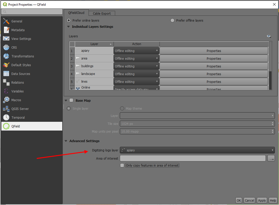
-
Set default values to the attributes using the positioning variables mentioned above.